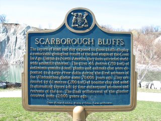
The layers of sand and clay exposed in these cliffs display a remarkable geological record of the last stages of the Great Ice Age. Unique in North America, they have attracted worldwide scientific interest. The first 46 metres (150 feet) of sediments contain fossil plants and animals that were deposited in a large river delta during the first advance of the Wisconsinan glacier some 70,000 years ago. They are covered by 61 metres (200 feet) of boulder clay and sand in alternating layers left by four subsequent advances and retreats of ice. The final withdrawal of the glacier occurred some 12,000 years ago.Did you know that Scarborough was named after the bluffs:
The Scarborough Bluffs are an escarpment in Scarborough, Ontario along the shoreline of Lake Ontario. They run from the foot of Victoria Park Avenue in the West to the mouth of Highland Creek in the east. However, the escarpment continues westward inland, running between Kingston Road and Queen Street East, pausing over the Don Valley, and continuing on the north side of Davenport Avenue. The escarpment forms the old shoreline of Lake Iroquois, formed after the last ice age.
It was named after Scarborough, England by Elizabeth Simcoe, the wife of John Graves Simcoe, the first lieutenant governor of Upper Canada. The bluffs along Scarborough's Lake Ontario shores reminded her of the limestone cliffs in Scarborough, England. In her diary, she wrote, "The [eastern] shore is extremely bold, and has the appearance of chalk cliffs, but I believe they are only white sand. They appeared so well that we talked of building a summer residence there and calling it Scarborough."[1]
A park created from fill has been built in the lake off the cliffside; named Bluffers Park, it is accessible from the foot of Brimley Road.
A stylized version of The Bluffs appeared prominently on the old flag of the City of Scarborough.


2 comments:
Home! :D
hey !
the bluffs! my house was about 10 houses to the west of your pictures. no one ever knows about them.
i'm not in toronto any more and really miss the bluffs and the big water.
on foggy days looking off the bluffs is really weird. sometimes we would look down on helicopters as they would fly by surveying the bluffs.
the big spiky part in your photo is generally referred to as the 'cathedral bluffs.'
one of the communities on the bluffs is called birchcliff. it was a popular spot for rich folks to build cottages way back in the day.
thanks!
you made my day when i found this post!
Post a Comment